
Twenty-one years after an earthquake tore through Kashmir and exposed the fragility of its buildings, the region is still waiting for something more consequential than a new line on a seismic map.
The debate over whether Jammu and Kashmir belongs in seismic Zone IV, Zone V or a newly proposed Zone VI has intensified in recent months. But beneath the argument over classifications lies a more uncomfortable question: what has actually been done to make Kashmir safer?
The answer, by the government’s own account, remains limited.
In February, the Jammu and Kashmir administration constituted a High-Level Committee for Hazard, Vulnerability and Risk Assessment, or HVRA, to examine the region’s exposure to earthquakes and other hazards. During the J&K Legislative Assembly’s September session, the government said the assessment was still being carried out and that future plans and policies would follow its findings.
More than two decades after the 2005 earthquake, there is therefore still no comprehensive, government-led assessment on which a long-term earthquake mitigation strategy for Kashmir can rest.
Meanwhile, the landscape that will determine the consequences of the next major earthquake has continued to change.
Cities have expanded. Buildings have grown taller and denser. Roads, bridges, hospitals and other critical infrastructure have multiplied. Srinagar’s urban footprint has spread across low-lying areas and floodplains, while construction has continued in a region where earthquakes are not an abstract possibility but a recurring geological reality.
The risk has not disappeared because the classification has changed.
On March 3, 2026, the Bureau of Indian Standards put on hold its revised earthquake design code, nearly four months after it had proposed a new Zone VI for much of the Himalayan region, including large parts of Kashmir.
The proposed framework represented a significant shift in the way earthquake hazard was assessed in India. It sought to move beyond the country’s traditional fixed-zone system toward a more probability-based understanding of ground motion.
But the stricter framework also raised concerns among government agencies and industry stakeholders over its cost and implementation implications. More demanding construction standards could increase building costs and complicate infrastructure and development projects, particularly in areas already facing difficult terrain and economic constraints.
With the withdrawal of the revised code, J&K reverted to the earlier framework under which different parts of the Union Territory fall within Zones IV and V.
For residents, however, the bureaucratic movement between zones offers little comfort.
The earth beneath Kashmir did not become less dangerous on March 3.
Nor did the buildings become stronger.
The 2005 earthquake remains the clearest warning.
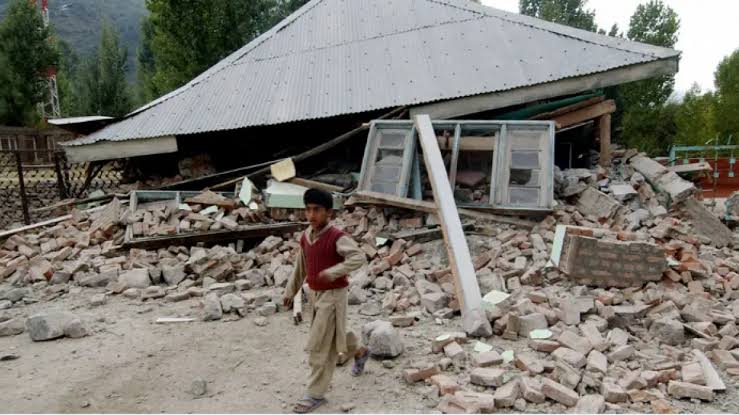
On Oct. 8, 2005, a magnitude 7.4 earthquake struck the Kashmir region, killing thousands and causing widespread destruction across Jammu and Kashmir. Official post-earthquake documentation recorded nearly 29,000 houses as fully damaged and more than 83,000 as partially damaged.
Uri, Kupwara, Baramulla, Anantnag, Pulwama and Budgam were among the worst-affected areas.
The assessment also documented a familiar vulnerability: stone and brick buildings, particularly those poorly constructed or lacking earthquake-resistant features, performed badly under severe shaking.
The lesson was not simply that Kashmir was located in an earthquake-prone zone.
It was that buildings could turn a natural hazard into a disaster.
Twenty-one years later, that distinction remains crucial.
A seismic zone is a description of earthquake hazard. It provides a framework for construction standards and engineering design.
It is not a prediction of how many buildings will collapse when the ground moves.
The eventual scale of destruction depends on what has been built on that ground.
The quality of construction matters. So does adherence to building codes. So do the age and structural condition of buildings, local soil conditions, population density and the resilience of hospitals, schools, bridges, roads, power networks, water systems and other critical infrastructure.
A highly hazardous area can reduce its losses through strong construction and preparedness.
A moderately hazardous area can suffer catastrophic damage if its buildings are weak and its emergency systems are unprepared.
That is why the argument over Zone V or Zone VI risks becoming a distraction if it is not accompanied by action on the ground.
In Kashmir, there is another complication: the ground itself can amplify the consequences of an earthquake.
A 2026 geotechnical study of Srinagar found that large parts of the city have high to severe susceptibility to earthquake-induced soil liquefaction. The risk is particularly significant along the Jhelum, where loose alluvial deposits and shallow groundwater can make the ground substantially more vulnerable during strong shaking.
Liquefaction can cause apparently solid ground to lose much of its strength during an earthquake. Buildings can tilt, settle or suffer structural damage even when the shaking itself has not directly caused their failure.
For a rapidly urbanising city built along a major river and on unconsolidated deposits, that is not a marginal engineering concern.
It is a question of urban survival.
The most troubling aspect of Kashmir’s seismic vulnerability is not that scientists are still refining the maps.
Earthquake science evolves. Hazard assessments are updated. Building standards change as engineers develop better models of seismic risk.
The concern is that the period since 2005 has not produced a transformation of Kashmir’s built environment commensurate with the warning delivered by that earthquake.
The 2005 disaster provided an extraordinary opportunity to inspect vulnerable structures, strengthen public buildings, enforce construction standards, educate homeowners and masons, develop earthquake-resistant construction practices and prepare emergency services for a major urban disaster.
Yet the government is now undertaking the kind of vulnerability assessment that should form the foundation of such a programme.
The administration says policies will follow the HVRA assessment.
That means the region remains, in effect, between diagnosis and treatment.
A long-term mitigation programme has not yet emerged from the latest assessment process.
For Kashmir, that delay matters because earthquakes do not wait for administrative timelines.
A building constructed today may remain standing for decades. If its structural design ignores seismic forces, the decision made during construction becomes a future liability.
Every additional floor, road cut, commercial complex or public building constructed without adequate attention to local seismic and geotechnical conditions can increase the potential cost of the next disaster.
There is an obvious reason governments hesitate to impose stricter seismic requirements.
Resilient construction costs money.
Engineered structures, stronger foundations, structural reinforcement, seismic detailing and stricter inspection can raise upfront construction costs. Retrofitting existing buildings is even more complicated.
For homeowners already struggling with the cost of construction, additional requirements can appear burdensome.
For governments, bringing thousands of existing public buildings up to modern standards is an expensive undertaking.
For businesses and developers, stronger regulations can affect project economics.
But the alternative is not free.
The 2005 earthquake demonstrated that the cost of structural failure is measured not only in damaged buildings but in lives, displaced families, disrupted schools, destroyed livelihoods and prolonged economic disruption.
The question for policymakers should therefore not be whether resilience costs more.
It does.
The question is whether Kashmir can afford to keep building without adequately paying that cost in advance.
The answer is likely to depend on how governments approach the problem.
Seismic safety cannot be reduced to imposing a tougher code on new construction and leaving the existing building stock untouched.
It requires a programme that identifies the most vulnerable structures, prioritises critical facilities, trains engineers and masons, improves enforcement and inspection, develops retrofit standards and makes compliance realistic for ordinary homeowners.
Hospitals and emergency facilities should be among the first structures assessed.
Schools present another obvious priority. A major earthquake during school hours could turn structural weakness into a mass-casualty event.
Bridges, communication networks, electricity infrastructure and water systems would also determine how quickly Kashmir could recover after a major earthquake.
There is also a policy paradox.
The government says it needs a comprehensive assessment before formulating long-term mitigation policies.
That is reasonable.
But some measures do not require waiting for every uncertainty to be resolved.
The 2005 earthquake already established that poorly built structures can fail.
Kashmir’s geological setting is already known to be seismically active.
The vulnerability of older masonry structures is well understood.
The need for earthquake-resistant construction is not dependent on whether the final map calls an area Zone IV, V or VI.
Waiting for a perfect classification before acting can therefore become another form of delay.
The most useful outcome of the current HVRA process would be one that moves beyond producing another report.
It should identify specific buildings, neighbourhoods and infrastructure at risk and assign clear responsibilities for reducing that risk.
It should also make public the criteria by which vulnerability is being assessed.
For residents, the crucial question is not what colour their district appears on a seismic map.
It is whether the house they live in is likely to withstand strong shaking.
The next major earthquake will not test the sophistication of a seismic classification.
It will test the quality of Kashmir’s buildings.
It will test whether hospitals can remain functional, whether roads and bridges remain usable, whether emergency services can operate, whether communication networks survive and whether government agencies know who is responsible for what in the first hours after a disaster.
It will test decisions made long before the shaking begins.
That is why the Zone VI controversy should be treated as a warning rather than as the central issue.
If the revised BIS framework eventually returns, Kashmir should be prepared to meet it. If it does not, the government can still adopt standards that reflect the region’s actual risk.
But changing the label without changing the built environment would accomplish little.
Twenty-one years after the 2005 earthquake, Kashmir does not primarily need another argument over which seismic zone appears on the map.
It needs a systematic programme of risk reduction.
That means assessing what exists, enforcing standards on what is being built, strengthening what can be saved and replacing what cannot.
The government’s new vulnerability assessment may provide the beginning of such a process.
But until that assessment becomes a funded, enforceable programme of mitigation, the most important fact about Kashmir’s seismic risk will remain unchanged:
The next earthquake will not care whether the map says Zone IV, Zone V or Zone VI.
About the Author
Amir Yaseen is a Srinagar-based journalist interested in Kashmir, policy, progress, and the human stories shaping everyday life.