
A dangerous bend on a mountain road can become familiar long before it becomes safe. Drivers learn to slow down, passengers recognise the stretch and residents know where vehicles have gone off the road. But familiarity is not a substitute for engineering. In Jammu and Kashmir, hundreds of identified accident black spots remain without full rectification, leaving a substantial gap between the recognition of danger and the work required to reduce it.
The figures presented at a road-safety review chaired by Chief Secretary Atal Dulloo on October 5 show the scale of that gap. The Transport Commissioner had identified 367 black spots across the Union Territory. Of these, only 68 had been fully rectified. The status of the remaining 299 raises questions about the pace of corrective work, the availability of funds and the timelines authorities have set for making hazardous locations safer.
The review also recorded 756 road-accident deaths between January 1 and September 15, 2026. That is an average of about three deaths a day. The number of accidents during the period was 4,222, compared with 5,808 in 2024. The government has set a target of reducing annual fatalities to 600 or fewer by 2027 and 450 by 2030.
The figures are not a complete account of every crash or every dangerous stretch. They are a snapshot of the data presented to the administration, and the reporting period for 2026 ends in mid-September. But they reveal the pressure on a road network that includes steep gradients, narrow mountain corridors, sharp turns and routes exposed to weather and unstable slopes.
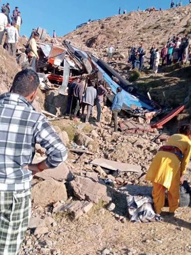
The review followed a bus accident at Gulli Gala on the Basantgarh–Ramnagar road in Udhampur district. The vehicle skidded off the road and plunged into a gorge. The original report recorded at least 10 injured passengers and said two people had died. It was not established whether the accident site was among the officially identified black spots. That distinction is important: an accident at a dangerous location should prompt scrutiny, but it should not be labelled a black-spot crash without confirmation.
A black spot is generally identified because a location or road section has a concentration of crashes or features associated with elevated risk. The purpose of identification is to help authorities prioritise intervention. Depending on the site, corrective work may involve improving road geometry, widening a carriageway, repairing a surface, installing crash barriers, improving drainage, adding signs and markings, clearing obstructions or changing the approach to a junction.
The number of locations identified is therefore only the first stage of a safety programme. Authorities must investigate why crashes occur, determine which engineering measures are appropriate, secure funds, complete the work and assess whether the changes reduce risk. A list of black spots can show that a hazard has been recognised; it cannot show that the hazard has been removed.
The October review said 165 black-spot rectification works had been audited by central agencies. The source material does not establish that all 165 had been completed or that they correspond to a separate category of fully rectified sites. The distinction between audited, under execution and completed work should be made clear in public reporting. Without a location-wise status, residents and road users cannot easily know which hazards have been addressed and which remain pending.
The wider road-safety figures show some movement in the right direction. The 4,222 accidents recorded in the 2026 reporting period were fewer than the 5,808 reported in 2024. The 756 fatalities up to mid-September were also below the 1,090 deaths recorded in 2024 for the full year. These comparisons need to be treated carefully because the periods are not identical. Even so, the daily loss of life remains high, and the target for 2027 requires a further reduction.
The administration said a safety audit of 1,433 roads had been completed. It had released Rs 11.60 crore to 15 districts under the Road Safety Fund for corrective interventions. Those measures suggest that the government is attempting to move beyond accident counting towards identifying and treating risks. The next question is how quickly the funding reaches projects and whether districts have the technical capacity to complete the work.
Road safety is often discussed as a matter of driver behaviour. Speeding, unsafe overtaking, fatigue, overloading and failure to use safety equipment can contribute to crashes. Enforcement and public awareness are necessary. But the condition and design of a road can determine whether a mistake becomes fatal. A vehicle that leaves a carriageway protected by a suitable crash barrier may have a different outcome from one that drops into a deep gorge. A blind curve with poor visibility creates a different risk from a curve with adequate sight distance and warning signs.
This is especially important in a mountainous region. Road geometry is constrained by slopes, rivers, settlements and geological conditions. Widening may be difficult or expensive, and a protective structure may require detailed engineering. Rain, snowfall and landslides can damage roads or alter conditions quickly. These difficulties make safety work more demanding, not less urgent.
The 299 black spots not fully rectified should not be treated as a single undifferentiated backlog. Some locations may need major engineering works; others may be addressed through signs, markings, barriers or maintenance. A transparent priority system could identify the sites with the highest crash history, the greatest severity of accidents and the most vulnerable road users. It could also set deadlines and publish progress so that a review meeting is followed by visible work on the ground.
The government’s target of no more than 600 fatalities by 2027 is close enough to require sustained action. If 756 people had already died by mid-September, the annual outcome would depend on the remaining months and the effectiveness of interventions. The target of 450 by 2030 requires a longer-term approach that combines engineering, enforcement, education, emergency care and reliable data.
Emergency response is an essential part of that system. The time between a crash and medical treatment can determine whether an injured person survives or suffers lasting harm. Trauma facilities, ambulance availability, communication from remote stretches and the ability to reach a crash site quickly all matter. The source material reports the road-safety review’s black-spot and fatality figures, but does not provide enough detail to assess the performance of emergency services across the region. That information should be part of future public reviews.
The same is true of the quality of accident data. Authorities need accurate location records, consistent definitions and information about the type and severity of each crash. If a site is identified as dangerous, residents should be able to see what work is planned, who is responsible and when it is expected to be completed. If a location is declared rectified, the decision should be supported by an assessment of the intervention and subsequent crash patterns.
The allocation of Rs 11.60 crore to 15 districts is a start, but money must translate into work. Districts need technical support to prepare estimates and execute improvements. Departments must coordinate where a road passes through different administrative jurisdictions or where traffic engineering, public works and policing responsibilities overlap. Delays in tendering, land availability or clearances should be identified rather than allowed to disappear into general assurances.
The figures also invite a broader question about the meaning of progress. Fewer accidents in one reporting period are encouraging, but they do not make an unsafe road safe. A reduction in fatalities should be sustained over time and accompanied by improvements at locations where crashes repeatedly occur. The measure of a road-safety programme is not how many reviews it holds or how many sites it lists, but whether people can travel without facing preventable hazards.
The road network connects villages to schools, hospitals, markets and employment. In remote districts, a road is not simply a route between two towns; it may be the only practical link to essential services. When a vehicle plunges into a gorge or a passenger dies on a familiar stretch, the consequences reach beyond the immediate crash. Families lose income and support, communities face grief and the promise of connectivity is weakened.
The 299 unresolved black spots give the administration a concrete task. Each is a location where a known risk still requires attention. The 756 deaths give that task a human measure. The government has set targets for 2027 and 2030; meeting them will depend on turning audits, funds and reviews into completed interventions, and on treating every preventable crash as a failure that can be investigated and addressed.
About the Author
Bisma Rafiq is interested in human resources and its role in improving journalism and media organisations. She is also a passionate storyteller.