
The road rarely announces the moment when it becomes dangerous.
It may begin as an ordinary stretch of asphalt, bending gently around a hillside, narrowing between a rock face and a drop, or disappearing into a pocket of fog. A driver passes through it once, then again, perhaps dozens of times. Familiarity settles in. The road becomes part of the landscape, almost invisible in its everydayness. And yet, somewhere along that curve, the balance between movement and disaster may be precariously thin.
In Jammu and Kashmir, and across the high roads of Ladakh, authorities have now put numbers to some of those places.
Seventy-four accident-prone black corridors have been identified across the two Union Territories, Union Road Transport and Highways Minister Nitin Gadkari informed Parliament. Seventy-three of them are in Jammu and Kashmir, while one has been identified in Kargil district of Ladakh.
The figures are more than an inventory of dangerous bends and treacherous stretches. They offer a stark outline of a region where roads are simultaneously lifelines and hazards—routes that carry people to schools, hospitals, markets and workplaces, but also highways that cut through mountains, cliffs, ravines and weather systems capable of changing within minutes.
The official data makes the human cost difficult to look away from.
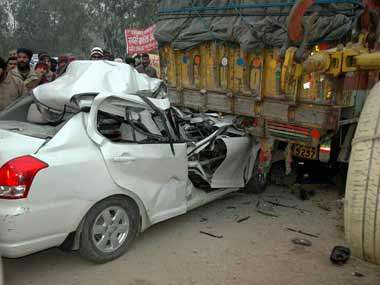
Between 2020 and 2024, Jammu and Kashmir recorded 10,251 road accidents. They left 1,350 people dead and 10,690 injured.
The fatalities, year by year, reveal no dramatic collapse in the danger. There were 258 deaths in 2020, followed by 268 in 2021 and 259 in 2022. The number climbed to 294 in 2023 before falling to 271 in 2024.
Taken together, the figures amount to nearly one road death every day during those five years.
The number is clinical. The reality is not.
Every statistic represents a journey interrupted: a passenger who never reached home, a worker whose commute ended on a mountain road, a family waiting for someone who did not return. In a region where roads often serve as the only practical connection between scattered settlements, the consequences of a crash can travel far beyond the immediate scene.
The distribution of the identified black corridors is itself revealing.
Jammu district accounts for the largest share, with 30 high-risk stretches. Samba follows with 14 and Kathua with 13. Reasi and Udhampur have four each, while Srinagar has three. Rajouri has two, and Baramulla and Kulgam have one each. Another corridor lies between Jammu and Samba.
The geography of these locations suggests a familiar tension in the region’s road network. Some of the busiest routes are also among the most unforgiving. Jammu, Samba and Kathua sit along important transportation arteries, carrying heavy volumes of traffic into and through the Union Territory. In the hills, the geometry changes: roads become narrower, gradients steeper, visibility less predictable and the consequences of a mistake more severe.
The phrase “black corridor” sounds technical, almost bureaucratic. But on the ground, such a designation is an admission that something has gone wrong repeatedly in the same place.
A road becomes a black spot – or part of a black corridor—not because of one unlucky incident, but because a pattern emerges. Vehicles lose control. Collisions recur. People die or suffer injuries. The road, the traffic and the surrounding environment begin to form a recognisable equation of risk.
The challenge in Jammu and Kashmir is that many of the factors contributing to that equation are difficult to eliminate.
Mountain roads are shaped by the terrain rather than the other way around. A highway cannot always be straightened or widened without cutting into slopes, destabilising mountainsides or altering drainage patterns. Snow, rain, landslides and falling rocks can transform a familiar route into an unpredictable one. During winter, ice can make even apparently safe stretches treacherous. During heavy rainfall, the same road may be threatened by erosion or debris.
And then there is the traffic itself.
As vehicle ownership expands and movement between districts increases, roads designed for a different era are being asked to absorb a heavier and faster flow. Commercial vehicles, buses, private cars, two-wheelers and long-distance traffic often share the same narrow corridors.
The result is a road-safety problem that cannot be reduced to driver behaviour alone.
Speeding and reckless overtaking may contribute to crashes. So may fatigue, poor visibility or distracted driving. But the broader question is whether roads are designed and managed in ways that anticipate human error.
A driver will make a mistake. A vehicle will lose control. A tyre will burst. A sudden obstacle will appear. The measure of a safe road is not whether nobody ever makes an error; it is whether the road gives people a chance to survive one.
That is why the identification of 74 black corridors matters.
The first step in solving a recurring problem is often to admit where it lives.
Yet identification is only the beginning. The real test will lie in what happens next: whether the dangerous stretches are engineered differently, whether signage improves, whether protective barriers are installed where needed, whether lighting and road markings are adequate, whether speed management is enforced, and whether accident investigations lead to changes in road design rather than simply another entry in a register.
The numbers from the five-year period also raise questions about the pace and effectiveness of intervention.
Jammu and Kashmir recorded more than 10,000 accidents in five years. The number of deaths fluctuated but remained stubbornly high. The peak in the available period came in 2023, when 294 people died. Even after the decline to 271 fatalities in 2024, the number remained higher than in 2020.
There is no single explanation for this persistence.
The region’s roads have been undergoing a transformation for years. New highways and tunnels have shortened travel times and opened previously isolated areas. Road infrastructure has become central to economic development and tourism. The same network that makes the mountains more accessible also carries more people through them.
Modernisation, in other words, creates its own responsibilities.
A faster road is not necessarily a safer road. A wider road can invite higher speeds. A newly engineered corridor can still contain dangerous intersections or poorly protected edges. A tunnel may eliminate one hazard while shifting traffic patterns elsewhere.
The road must therefore be understood as a system, not simply a strip of pavement.
That system includes the vehicle, the driver, the weather, the slope, the engineering, the emergency response and the time it takes for help to arrive.
In the mountains, that last element can be decisive.
A crash that might be survivable in an urban setting can become fatal when it occurs far from medical facilities, particularly if the victim is trapped or the road is blocked. The minutes immediately after an accident are often as important as the moments before it.
For families in remote parts of Jammu and Kashmir, the road is also a measure of access—to healthcare, education, employment and opportunity. When the road fails, the consequences can multiply.
This is what makes the black-corridor list more than a transport statistic. It is also a map of vulnerability.
Jammu’s 30 identified corridors deserve particular scrutiny, not merely because the district has the highest number, but because Jammu is one of the principal gateways into the region. Traffic arriving from outside the Union Territory converges with local movement. The roads are busy, the stakes are high, and the margin for error can be narrow.
Samba and Kathua, with 14 and 13 identified corridors respectively, tell a similar story. Together with Jammu, they account for the overwhelming majority of the identified dangerous stretches in the region.
But the smaller numbers elsewhere should not be mistaken for smaller risks.
One black corridor in Kulgam is still one too many if it repeatedly claims lives. A single dangerous stretch in Baramulla can have a devastating impact on the communities that use it. In mountain districts such as Reasi and Udhampur, even a small number of identified corridors may represent complex engineering challenges.
The road network is not simply a collection of locations. It is a chain. A weakness in one link can affect the journey as a whole.
The identification of a single black corridor in Kargil also carries a different kind of significance. Ladakh’s roads operate in an environment where altitude, weather and remoteness create extraordinary constraints. The road may be clear in the morning and hazardous by afternoon. The landscape can appear almost empty, but that emptiness itself can become a risk when an accident occurs far from assistance.
Road safety in such places requires an approach adapted to the terrain rather than borrowed wholesale from flatter regions.
The parliamentary data does not, by itself, explain what caused each accident or what measures are planned for each corridor. Nor does it tell us how many of the identified stretches have already received engineering interventions.
But it does something important.
It makes the problem visible.
For years, road accidents are often treated as isolated events: a collision here, a vehicle falling into a gorge there, a fatal crash on a highway that briefly becomes news before the next one replaces it. The cumulative toll is harder to see.
Until someone counts.
One thousand three hundred and fifty deaths in five years is not a series of unrelated tragedies. It is a public-safety challenge.
The 74 black corridors are the places where that challenge has become geographically legible.
Now comes the harder work.
A black corridor should not become a permanent category—a place identified, documented and then forgotten. The purpose of identifying danger is to remove it, reduce it or make it survivable.
That may require guardrails, crash barriers, better curves, improved drainage, rumble strips, lighting, speed controls, warning systems and clearer markings. It may require stricter enforcement and better driver education. It may require redesigning junctions or separating opposing traffic. And, in some places, it may require the kind of expensive engineering that mountain roads inevitably demand.
But the most important change may be conceptual.
The region’s roads must be designed around the idea that human life is the ultimate measure of infrastructure.
The mountains will remain. The weather will change. Vehicles will continue to travel. Drivers will occasionally make mistakes.
The road, however, can be made more forgiving.
For the families of the 1350 people who died between 2020 and 2024, that is too late. For the 10,690 people injured, the consequences may continue for years.
For everyone still travelling these roads, the question is whether the next journey will be different.
The map has identified the danger.
Now the roads must be made to remember the cost.
About the Author
Mir Suneem is a filmmaker and a postgraduate in filmmaking from Jamia Millia Islamia. With a strong grounding in film editing and narrative craft, she is drawn to stories the frame extends beyond the visible into the lived.