
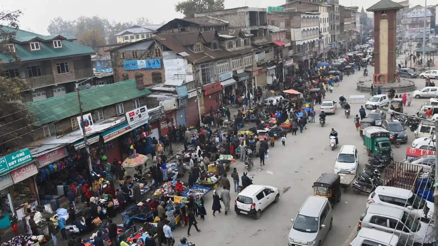
In downtown Srinagar, the distance between one building and the next can be measured in inches, while the lanes between them may be too narrow for emergency vehicles to pass. The arrangement is part of the city’s older urban fabric. It is also among the reasons a scientific assessment has identified large parts of the downtown area as especially vulnerable to earthquake damage.
Twenty-three of Srinagar’s 69 municipal wards fall into the high or very high physical-vulnerability categories, according to the study. Together, the areas cover nearly 17 square kilometres, about 7 percent of the city. Nine wards, accounting for 1.28 percent of the city, were classified as very highly vulnerable; another 14 wards, or 5.7 percent, were placed in the high category. Nineteen wards had moderate vulnerability, 17 low and 10 very low.
The study identifies a combination of factors: dense construction, narrow roads, limited open space and the possibility that neighbouring buildings could strike one another when the ground shakes. Uptown areas were assessed as relatively less vulnerable, in part because they have wider roads and lower building density.
One finding illustrates the scale of the problem. About 65 percent of Srinagar’s buildings face a high risk of structural pounding with a neighbouring structure on at least one side. During an earthquake, closely spaced buildings can collide as they move, damaging walls and structural elements. The risk is shaped not only by the strength of an individual building but also by the space left between it and the buildings around it.
The city’s building stock adds to the concern. Nearly 98 percent of structures are masonry buildings, the study says. Residential buildings account for 86.4 percent of the total and commercial buildings for 7.1 percent. Educational, religious, health, defence and other structures make up the remaining 6.5 percent. Aali Kadal has the highest proportion of masonry buildings, at 99.8 percent.
Two-storey buildings account for half of the city’s building stock, while 42 percent have three or more storeys. Single-storey structures make up 8 percent. The study records 307 buildings, or 0.12 percent, with more than three floors.
Density is particularly pronounced in parts of the old city. Against a citywide average of 10 buildings per hectare, 17 downtown wards have more than 15. Jamia Masjid has the highest recorded density, at 46 buildings per hectare, followed by Tarabal at 39 and Aali Kadal at 30. Bud Dal, by contrast, has one building per hectare.
Road access can complicate the response after an earthquake. Six wards — Syed Ali Akbar, Bana Mohalla, Bud Dal, Zindshah Sahib, Ganpatyar and Safa Kadal — have average road widths of less than seven feet, according to the assessment. Narrow passages may impede evacuation, the movement of rescue teams and the delivery of emergency supplies. A neighbourhood with limited open space may also have fewer places where residents can gather safely after a building has been damaged.
The researchers link the city’s vulnerability partly to unplanned urban growth and gaps in the implementation of successive master plans. Srinagar’s population rose from about 250,000 in 1961 to 1.5 million in 2011, placing growing pressure on housing, roads and civic infrastructure. The study argues that the expansion of the built environment has not always been matched by adequate planning.
The assessment was conducted by Midhat Fayaz, Professor Shakil Ahmad Romshoo, Irfan Rashid and Rakesh Chandra. The researchers used Cartosat-2 satellite imagery, geographic information system mapping and field surveys to examine six parameters across all 69 municipal wards. They collected 8,000 ground-validation points. The paper, titled “Earthquake vulnerability assessment of the built environment in the city of Srinagar, Kashmir Himalaya, using a geographic information system,” was published with funding from the Union Ministry of Earth Sciences.
The researchers recommend restricting new construction in densely populated and highly vulnerable areas, protecting open spaces that could serve as evacuation sites and retrofitting buildings that may not withstand strong shaking. They also call for emergency action plans, shelters, fire services and specialised medical facilities in vulnerable neighbourhoods. Stricter enforcement of building codes, earthquake-resistant construction and public-awareness programmes form part of the proposed response.
The study has an important boundary. It assesses the physical vulnerability of buildings and infrastructure; it does not measure the socioeconomic vulnerability of residents. The researchers recommend including those factors in future assessments. The capacity of households to evacuate, recover or rebuild can vary substantially, even within neighbourhoods that share similar physical risks.
A vulnerability map does not predict when an earthquake will occur. Nor does a ward’s classification mean that every building within it will suffer the same damage. It is a tool for identifying where the built environment may be more exposed and where detailed inspections and risk-reduction measures could be prioritised.
For downtown Srinagar, the findings turn familiar features of the urban landscape into questions of public safety. The narrow lane, the closely packed house and the absence of an open courtyard are not merely matters of convenience or architectural character. In an emergency, they can shape how quickly people get out and how effectively help can reach them.
The study’s recommendations require decisions that extend beyond disaster-management agencies. Planning authorities, municipal bodies, building regulators and residents all have a role in reducing exposure. Protecting open spaces means resisting construction pressure. Retrofitting requires identifying vulnerable structures and developing practical ways to strengthen them. Building-code enforcement must apply to new construction as well as additions to existing buildings.
Srinagar’s earthquake risk is not new. What the assessment provides is a more detailed account of how that risk is distributed across the city. The next step is to translate the map into ward-level planning, building assessments and emergency arrangements — before an earthquake tests the city’s ability to respond.
About the Author
Mir Suneem is a filmmaker and postgraduate in filmmaking from Jamia Millia Islamia, with a strong interest in editing and narrative craft.