


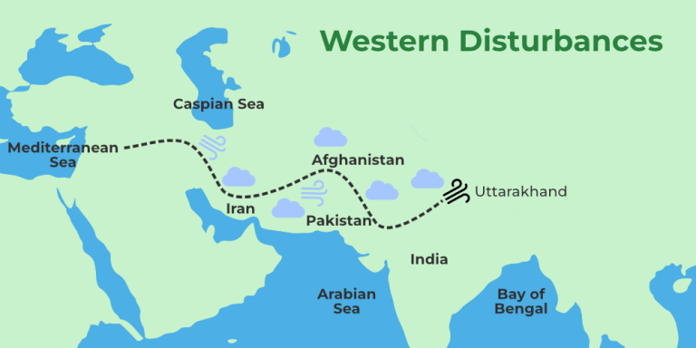
Kashmir Impulse Desk Srinagar, April 3 A fresh Western Disturbance swept across Jammu and Kashmir on Saturday, bringing widespread rainfall to Kashmir, lowering daytime temperatures and prompting warnings of continued unsettled weather in the days ahead. Rain began falling across Srinagar and adjoining areas by the afternoon, intensifying through the evening. According to the Meteorological
Kashmir Impulse Desk
Srinagar, April 3
A fresh Western Disturbance swept across Jammu and Kashmir on Saturday, bringing widespread rainfall to Kashmir, lowering daytime temperatures and prompting warnings of continued unsettled weather in the days ahead.
Rain began falling across Srinagar and adjoining areas by the afternoon, intensifying through the evening.
According to the Meteorological Department, Srinagar recorded 14 millimeters of rainfall, while Qazigund received 11.6 mm, Pahalgam 10.6 mm, Kupwara 8.7 mm, Kokernag 6.2 mm and Gulmarg 16.2 mm.
The system extended into parts of the Jammu region, where intermittent showers were also reported.
Daytime temperatures fell below seasonal norms across Kashmir.
Srinagar recorded a high of 17.3 degrees Celsius, Pahalgam 15.4 degrees Celsius, and Gulmarg 5.6 degrees Celsius, each registering a noticeable dip for early April.
Meteorological Department officials said precipitation was expected to persist through Saturday evening in the plains, with light snowfall likely in higher elevations.
Mountain passes, including Zojila, Sinthan Top, Margan Top, Mughal Road, Sadhna Top and Razdan Top, were forecast to receive fresh snowfall.
Director Meteorological Centre, Srinagar, Mukhtar Ahmad said the region would remain under the influence of successive Western Disturbances through April 10.
“Generally cloudy conditions with intermittent light to moderate rain and snowfall at higher reaches, accompanied by thunder, hailstorms and gusty winds, are expected to continue through April 4,” he said.
Ahmad that April 5 and 6 would likely bring partial cloud cover with isolated light rain, before another, more significant weather system arrives between April 7 and 9, bringing renewed precipitation and gusty winds.
A brief spell of light rain or snow may occur on April 10 and 11, followed by a period of relatively drier, though still cloudy, conditions through mid-April.
The department warned of thunderstorms, hailstorms, and winds reaching speeds of 40 to 50 km per hour during the current system and again early next week.
Short bursts of intense rainfall could trigger flash floods, landslides and waterlogging in low-lying areas.
Authorities have advised farmers to suspend agricultural operations and urged travellers to monitor weather and road conditions closely.
In Srinagar, district officials appealed to residents to limit nonessential travel.
People working near water bodies, including Dal Lake and the Jhelum River, were cautioned against venturing out without verifying safety conditions.
In the Jammu division, persistent rainfall disrupted daily life in several districts, particularly in Rajouri, where heavy downpours on Friday brought routine activity to a near standstill.
Officials said all districts in the division recorded rainfall, with moderate to heavy precipitation in some areas.
Upper reaches of Rajouri, Poonch, Reasi, Ramban, Doda, and Kishtwar also received fresh snowfall, further lowering temperatures.
Transportation and outdoor activities were affected across the region, with residents reporting difficulties in movement amid continuing adverse weather.
Authorities urged caution, warning that the wet spell was likely to persist over the coming days.
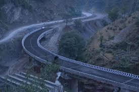
Rainfall also triggered a mudslide along the Udhampur-Banihal stretch of the Srinagar-Jammu National Highway, briefly disrupting traffic near Ramsu on Friday afternoon.
Officials said the highway was blocked for nearly an hour before crews cleared the debris and restored movement. Additional incidents of shooting stones and minor landslides were reported near Jaswal Bridge in the Karool area, where traffic was temporarily diverted.
Teams from the National Highways Authority of India were deployed to clear affected stretches.
Traffic authorities have advised commuters to travel only after confirming road conditions and to avoid night journeys, citing the heightened risk of landslides and ongoing construction activity. Despite the disruptions, passenger and goods vehicles continued to move, though at reduced speeds.
The Kishtwar-Sinthan Top-Anantnag road remained closed due to heavy snowfall, further affecting connectivity.
The Mughal Road, a key link between the Pir Panjal districts and Kashmir, was closed on Friday after fresh snowfall near Pir Ki Gali rendered the route unsafe.
Officials said snow accumulation prompted a precautionary suspension of traffic.
While the Border Roads Organisation is prepared to undertake clearance operations, continued rainfall has delayed efforts.
The road is expected to remain closed at least through Saturday morning, with reopening contingent on improvements in weather and road conditions.
Authorities have urged commuters to avoid the route until further notice and to follow official advisories as conditions continue to evolve.


Leave a Comment
Your email address will not be published. Required fields are marked with *