

Kashmir Impulse Desk
Srinagar, Nov 12
Rain lashed the plains and snowfall covered higher reaches of Jammu and Kashmir on Thursday as a strong Western Disturbance brought a fresh spell of precipitation, sharply lowering daytime temperatures and disrupting traffic on several mountain roads.
The Meteorological Department has forecast moderate to heavy rain and snowfall across J&K over the next two days, with isolated thunderstorms, hailstorms and gusty winds also likely.
Light to moderate rainfall was recorded across north, central, and south Kashmir.
Gulmarg received 14.4 mm of rainfall in the preceding 12 hours, followed by Kupwara with 14.3 mm. Srinagar recorded 1.6 mm and Pahalgam 3.4 mm, while the plains of south Kashmir received only traces of rainfall.
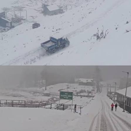
Higher reaches, including Afarwat and Kongdori in Gulmarg, Razdan Pass, Gurez and Tulail in Bandipora, Sadhna Top, Keran and Machail in Kupwara, and Minamarg, Zero Point and Zojila Pass near Sonamarg, received three to six inches of snowfall, a Meteorological Department official said.
Snowfall was also reported from Peer Ki Gali on the Mughal Road, Margan Top connecting the Valley with Warwan and Marwah, and Sinthan Top on the Kashmir-Kishtwar route.
Higher reaches of the Pir Panjal and Chenab Valley also received snow.
Some upper reaches had recorded one to three inches of snowfall on Tuesday and Wednesday.
Director Meteorological Centre Srinagar Mukhtar Ahmad said a stronger Western Disturbance had followed an earlier weak system, bringing moderate precipitation to several parts of Jammu and Kashmir.
He said higher mountain peaks could receive one to two feet of snow, while tourist destinations were likely to experience light snowfall.
The weather system is expected to bring the season’s first snowfall to Doodhpathri, Pahalgam, Gulmarg and Sonamarg, Ahmad said.
Srinagar recorded a maximum temperature of 10 degrees Celsius on Thursday, 5.5 degrees below normal and its lowest daytime temperature so far this month.
Pahalgam recorded a maximum of 10.3 degrees Celsius, 2.7 degrees below normal, while Gulmarg recorded 4 degrees, 5.2 degrees below normal.
Qazigund recorded 13 degrees, 2.8 degrees below normal; Kokernag 13.5 degrees, 0.4 degrees below normal, and Kupwara 8.4 degrees, 7.6 degrees below normal.
Cloud cover kept minimum temperatures relatively high. Srinagar recorded a minimum of 5.6 degrees Celsius, 1.3 degrees above normal.
Qazigund recorded 5.8 degrees, Kokernag 6.4 degrees, Kupwara 3.7 degrees and Pahalgam 2.7 degrees.
Gulmarg recorded a minimum of minus 0.6 degrees Celsius.
In Jammu division, Jammu city recorded a maximum temperature of 27.1 degrees Celsius. Banihal recorded 17.1 degrees, Batote 20.9 degrees, Katra 24 degrees and Bhaderwah 18 degrees.
The fresh snowfall disrupted traffic on several mountain routes, including the Srinagar-Leh highway via Zojila, Mughal Road, Sinthan Top, Margan Top, Razdan Pass and Sadhna Pass.
Authorities closed the Mughal Road after fresh snowfall and rain made the Peer Ki Gali stretch slippery.
The road connects Kashmir with the twin districts of Rajouri and Poonch.
The Srinagar-Leh highway was also closed after snowfall at Zojila Pass and Sonamarg. Zojila received one to two inches of snow, while Sonamarg experienced the season’s first snowfall.
The Border Roads Organisation deployed machinery for snow clearance.
An official said traffic would be restored after clearance work was completed and weather conditions improved.
Police said only four-wheel-drive vehicles or those equipped with anti-skid chains would be allowed to proceed towards Sonamarg from Gagengar.
The Bandipora district administration temporarily barred tourists from visiting Gurez and Tulail in view of the weather forecast.
Visitors already staying in the twin valleys were advised to coordinate their departure with the District Control Room.
In Kupwara, upper reaches, including Z-Gali in Machil, Ferkhian Top in Keran, Sadhna Top, Budnamal, Kumkadi and Jumagund, received five to six inches of snow.
Deputy Commissioner Abhishek Sharma advised residents of the upper reaches against unnecessary travel.
The administration also directed commuters using the Kupwara-Tangdhar road via Sadhna Top to carry anti-skid chains.
No vehicle will be allowed towards Sadhna Top from TCP Bagballa and TCP Chowkibal without anti-skid chains, an official advisory said.
Similar instructions were issued for vehicles travelling to Keran, Machil, Budnamal, Jumagund and Kumkadi.
Light snowfall was also reported from higher reaches of Rajouri and Poonch.
The Motor Vehicles Department in Rajouri advised motorists against driving on snow-covered roads and warned them not to park vehicles along vulnerable road edges prone to landslides.
Meanwhile, the Srinagar-Jammu National Highway remained open for two-way traffic, although movement was slow at several stretches between Udhampur and Banihal because of construction work, road widening and narrow carriageways.
Uneven road surfaces at Dewal in Udhampur and the narrow stretch between Maroog and Kishtwari Pather in Ramban continued to hamper traffic.
Restrictions on Kashmir-bound oil and gas tankers also remained in force along the Digdol-Khooni Nalla stretch because of highway widening work. Tankers have been allowed to cross the Chenani-Nashri Tunnel between 5 pm and 5 am, while movement along the Digdol-Khooni Nalla stretch remains restricted between 7 am and 7 pm.
Traffic authorities advised commuters to travel during daylight hours and exercise caution along the Ramban-Banihal stretch because of the possibility of landslides, shooting stones and ongoing construction.
The Meteorological Department has forecast generally cloudy weather with light to moderate rain in the plains and snowfall in higher reaches at most places on November 12 and 13.
Moderate to heavy precipitation is likely from Thursday forenoon until late Friday afternoon. A brief spell of light rain or snow is possible at isolated places on November 14 and 15, followed by generally dry weather from November 16 to 20.
Daytime temperatures are expected to fall by six to eight degrees Celsius during November 12 and 13.
Thunderstorms, hailstorms and gusty winds are also likely in a few places.
The department advised farmers to safely store harvested crops and urged travellers, transporters and tourists to follow official traffic advisories.